Here we are: the latest reading fun for gliding freaks: we have lots of great articles for you in the new issue! We start with a look back at Aero 2024, where gliding took part again for the first time, learn how to fly safely on a slope in our cover story and see whether thermals really always rise vertically. Our author then takes you to the Pyrenees between France and Spain, where we learn how to analyze data from glider flights and why motor glider pilots should pay particular attention to their flight preparation. Then it’s off to the south of Australia, where gliding can be experienced in seemingly endless space without many restrictions. But there are also great views very close by, namely at Lake Constance, where an airfield borders directly on a nature reserve and where “normal” flights can also be enjoyed. Is this the future of gliding? Or spectacular flights with top equipment? It’s amazing what young glider pilots have told us. And finally, a look back to 1924 to three daring men in their flying boxes.
And now: look forward to the new issue – and if you haven’t subscribed to the magazine: pick it up at the newsstand or order directly at the publishing house.
And now a brief look at the current articles:
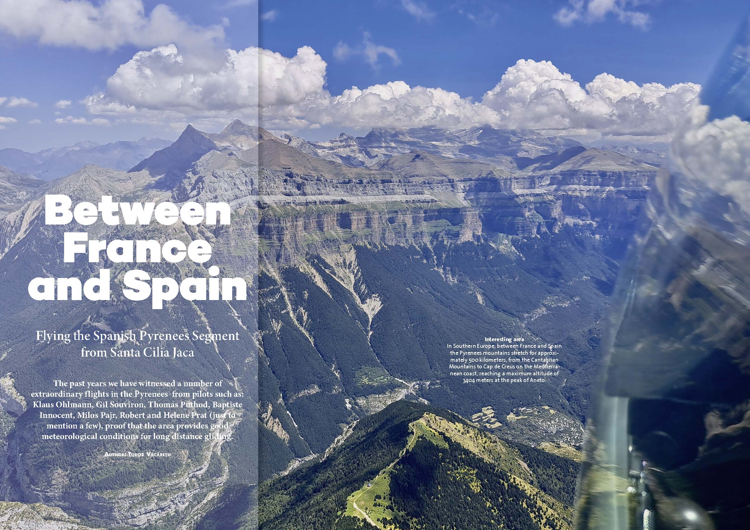
Along the Pyrenees are a number of gliding airfields which are active through the normal gliding season. On the Southern side are the Spanish airfields of Santa Cilia Jaca and La Cerdanya. On the Northern side the following French airfields can be found: Puivert, Saint Girons, Bagnères de Luchon, Saint Gaudens, Tarbes, Oloron, and Itxassou. On the Central axis of the Pyrenees, on the Eastern side, the French airfield of La Llagonne is situated, possibly the highest European gliding airfield with an elevation of 1711 meters.
The general weather situation in the Pyrenees is of Northern circulation with most of the rain falling on the French side while the Spanish side sits in the rain-shadow staying dry and sunny. During the months of July and August thunderstorms can develop late in the afternoon or in the evening most commonly when the wind blows from the South during the hot summer days. Further there are numerous microclimates along the mountain chain and where to find the best weather can be difficult to predict.
From the point of view of the glider pilot, all forms of lift can be expected while flying here: ridge, thermals, wave and convergence. The best form of lift for long distance gliding flights in the Pyrenees is of course wave lift, encountered with Northerly and Southerly winds. However, long distance flights can be done with thermals as well in the Pyrenees, a good example here serves the flight of Gorka Elduayen www.onlinecontest.org/olc-3.0/gliding/flightinfo.html?dsId=8532752&f_map= with a performance of 823 kilometers.
The standard gliding flight route in the Pyrenees (give or take) is from Santa Cilia Jaca to La Cerdanya or the other way around, confirmed also by the WeGlide segment: Pyrenees.
Last summer I had the chance to fly from Santa Cilia Jaca and fly the entire WeGlide Pyrenees Segment in thermals. Located in the Western Pyrenees in the Aragon Valley, at an elevation of 684 meters with an asphalt runway (direction 09/27) of 850 meters Santa Cilia offers air-tow possibilities.
The basic strategy here is either to take a high tow and start in the high mountains North of the airfield or take a tow to the lower hills in the immediate vicinity of the airfield, but climbing in the upper mountains will take time and sometimes it can be very difficult to get away from the lower hills due to inversion in the valley. With respect to starting strategy I have made a few mistakes in the period I flew at Santa Cilia Jaca. Because I released too early I could not get away further than the local hills.
On other days I towed to the high mountains before the thermals started to develop, which forced me to descend to the lower mountains where I could maintain my altitude until the weather started to develop. I guess I still have to learn a thing or two about flying in this beautiful region.
Climbing to the high mountains North of the airfield is done in three steps: Step 1: the lower hills, Step 2: the middle sized mountains and Step 3: the high mountains, or as you will hear it in the Spanish briefings Escalón 1, 2, 3 (…)
Exciting? Ok, you can read the whole article in the current issue, which you can order here.
